It is sadly now common knowledge that populations of pollinators, like bees and butterflies, are declining globally. In the UK, in particular, the decrease in plant diversity and pollinator-friendly habitats is contributing majorly to these declines. As many insects are unable to travel very far and struggle to move through areas with no suitable food or resting places, populations are becoming more isolated and vulnerable. One solution to halt insect declines is therefore to link up the wildflower-rich habitats across the country, including in our towns and cities. The 2019 State of Nature Report emphasises that urban areas have the potential to support higher pollinator species richness than non-urban areas, given that allotments and residential gardens can be pollinator hotspots. In Greater London, we need to help these hotspots reach their full pollinator potential and improve plant diversity in other green spaces across the capital to create a strong network for our irreplaceable pollinators.
An Introduction to B-Lines
To encourage the creation and improvement of wildflower-rich habitats that are so vital for pollinators, Buglife devised the B-Line strategy, where the “B” stands for Biodiversity and encompasses all pollinators, not just bees! B-Lines are pathways that link up existing pollinator friendly habitats which can be used to focus efforts of habitat creation and restoration along their length. The strategy aims for 150,000 hectares of created and restored flower-rich habitat across the UK. The current B-Line network covers England, Wales, Scotland and Northern Ireland and is already showing how joining-up habitats can improve pollinator mobility and survival. The full B-Line map can be seen here.

The B-Line strategy principles state that there should be at least one East-West and one North-South B-Line per county. The Greater London North-South B-Line was established nearly ten years ago, and you can read about it here in Caroline Birchall’s GiGLer article.
There is yet to be an East-West line, until now…
London’s New East-West B-Line
In 2022, GiGL were approached by Buglife to carry out the modelling work needed to create a new B-Line going East-West across Greater London. With Buglife’s well established methodology combined with GiGL’s data and technical expertise, the project was a success! It involved four stages.
1. Gathering data
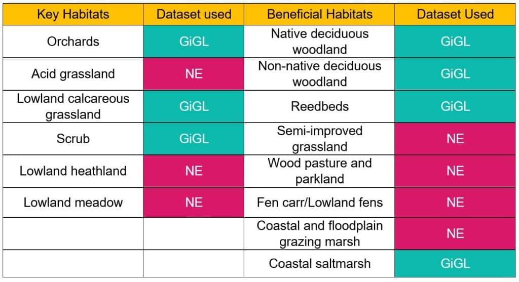
To link up wildflower-rich habitat you first need to know where you can find them. GiGL selected the most comprehensive and accurate data for each habitat type, meaning a mixture of GiGL’s habitat and land-use (HLU) data and Natural England’s priority habitat data were used in the final product (see table below). A total of 14 habitat types were categorised into Key and Beneficial depending on their significance to pollinators. Key habitats are those that are likely to be the most wildflower-rich so have the highest priority when making a B-Line, while beneficial habitats are ones that are likely to support pollinator populations and their movement across the landscape.

2. Creating a core habitat layer
Habitat areas of less than 2ha were removed as these were assumed to be too small to have a significant influence on pollinator movement. Different sized buffers were applied to the remaining habitat areas depending on their status (key or beneficial) and their overlap with Sites of Special Scientific Interest (SSSIs), with larger buffers being given to key habitats that intersect a SSSI. These were then combined into one core habitat layer representing the best pollinator habitats in Greater London.
3. Linking up core habitats
To construct possible routes between these core habitats, the Linkage Mapper tool was used. This is an open access toolbox developed by a global team of ecologists and coders, which can be used within the GIS software, ArcGIS Pro. More can be read about the tool here.
Lines of least resistance, or most pollinator friendly routes, were created between the core habitats using a resistance layer. In this instance the Land Cover Map 2007 dataset produced by the Centre of Ecology and Hydrology (CEH) was used. The different land cover types were scored based on their predicted suitability for pollinators, so the model could create routes that travelled through the most suitable habitat types.
4. Choosing the final B-Line
There is never one clear option of where to draw a final B-Line as there will always be multiple ways to link up core habitats across a landscape. Therefore, an important final step in the process was to gather a team of experts with local habitat and pollinator knowledge of London, to discuss where the optimum place for the line would be that coincides with the modelled data. The final decision also considered the best way to unite with the existing B-Line network.
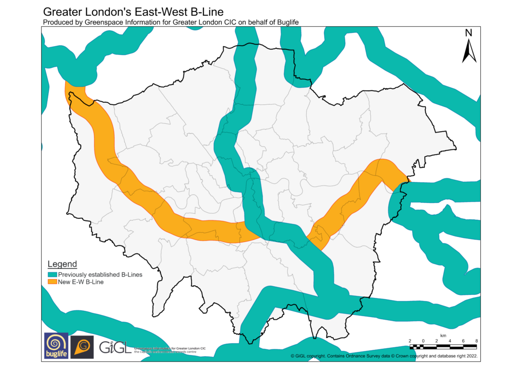
The final line can be seen below.

Next Steps
Now that the Greater London B-Lines have been established, it is time for people to come together to help improve those vital habitats. Anyone can contribute to the B-Line project, schools, councils, businesses, gardeners and community groups, to name a few, and any progress towards improving London’s pollinator populations can be contributed to the online B-Line map, here. These efforts will not only have benefits for pollinator populations but also for bringing more nature to more people. To help with this, Buglife have just kicked off a new enterprise – Get London Buzzing. This aims to train local communities in creating, monitoring and conserving pollinator habitats, with a particular focus on those areas that fall within London’s B-Lines. They will be partnering with schools to empower and educate young people about nature, as well as working with landowners to increase the network of wildflower-rich habitat across the city. Hopefully over the coming years we will see a real increase in pollinator numbers from the establishment and influence of the B-Line network.
If you want to get involved and help pollinators in your local area (even if you don’t live within a B-Line) you can find out more on the BugLife website here.

I live in Lambeth and my local park is Brockwell Park. There’s a wildflower meadow in the park, which I believe is on the North-South B-line. Myself and some other park users recently did a bioblitz of the meadow and its immediate environs, recording about 100 species of its flora and fauna. Looking at your map of the East-West B-line, I’m wondering if the meadow might be on that too? Is it possible to get higher resolution versions of either/both of the maps for these B-lines?
Hello, thank you for your comment and it’s great to hear of the work being done to record species in your local park.
BugLife have an interactive map of B-Lines here: https://www.buglife.org.uk/our-work/b-lines/. On this you can see that Brockwell Park is firmly within the EW and NS London B-Lines. On the same link you can find out how to add your pollinator project to the map and other ways to get involved.
We’d love to know if you have or are planning to share records from the BioBlitz with GiGL. If you haven’t, please don’t hesitate to get in touch with our Community Officer Victoria (victoria.kleanthous@gigl.org.uk).
Hi Amy, thanks for your reply. We will be sharing the records from this initiative with GiGL, either via Lambeth council’s ecologist, or (in the case of moths) via the Surrey county moths recorder. We have produced a report on our initiative, which I have just sent to GiGL Community Officer Victoria.