This site follows the Dollis Brook as it winds its way through farmland and playing fields for some six kilometres between Arkley and Woodside Park. It includes a section within the Totteridge Fields Metropolitan site. For much of its course, the brook meanders between natural banks, with clear water and a clay or gravel bed. The surrounding countryside (including Duck’s Island, Wyatt’s Open Space, Brook Farm Open Space and Whetstone Stray) features some flower-rich meadows, divided by fine old hedges and small areas of woodland and scrub.
Local Wildlife Site
Accessible Sites of Importance for Nature Conservation
Upper Dollis Brook
Borough: Barnet
Grade: Borough Grade I
Access: Free public access (all/most of site)
Area: 39.62 ha
Description
Wildlife
The brook is largely overhung by trees, making it too shaded for aquatic plants. Yellow iris, water-pepper, fool's watercress, great reedmace, marsh woundwort and branched bur-reed grow on the banks. Kingfishers, grey wagtails and moorhens can be seen along the stream. The nearby meadows are home to plants such as sneezewort, oval sedge, devil's-bit scabious, cuckooflower, meadow crane's-bill and meadowsweet. The hedges include some uncommon shrubs such as spindle and buckthorn.Facilities
The Dollis Valley Greenwalk follows the Dollis Brook through this section, and the London LOOP runs along part of it.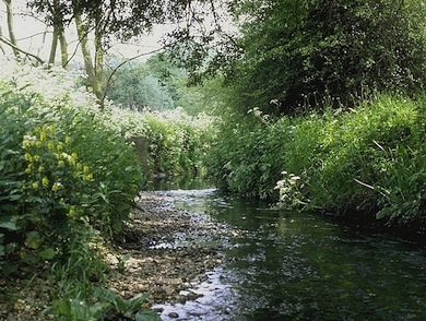
View of the Dollis Brook © Jan Hewlett
Feedback
Have a question or a comment for this site, or notice anything missing or out of date? Please contact us.