The London Geodiversity Partnership (LGP) contributes valuable expertise and insights on geodiversity in the city, helping to identify and conserve sites of geological importance and interest. GiGL have collaborated with the LGP since 2012 to ensure that crucial geodiversity data is accessible to planners, researchers, and the public to support informed decision-making in conservation and development. The partnership is significant in helping to preserve London’s modern and prehistoric heritage, enhancing public understanding at sites where biodiversity also often coincides. Read more about the LGP in June’s GiGLer article here.
Reinstating Branch Hill pond is a collaborative project initiated by the local Redington Frognal Association and with a big contribution from the City of London Corporation who own and manage Hampstead Heath.
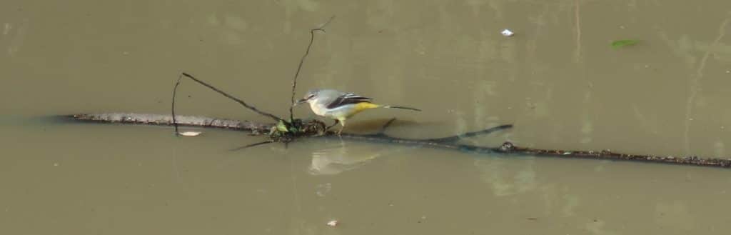
Ponds and the wildlife that they harbour are a rare and dwindling occurrence in urban London. Fed only by rainwater or groundwater, ponds change rapidly due to both climatic conditions – heatwaves worsened by the urban heat effect, climate change-exacerbated unpredictable rainfall patterns – and general neglect which can limit the natural potential of a pond. But when ponds thrive, they provide a refuge of the suite of habitats needed for plants, invertebrates and amphibians to fulfil different stages of their life cycles, attract the predators of pond life like birds and mammals and provide endless fascination for pond dippers. From ice-age ponds to the pits carved by human activity, ponds also provide plenty of intrigue for geologists.
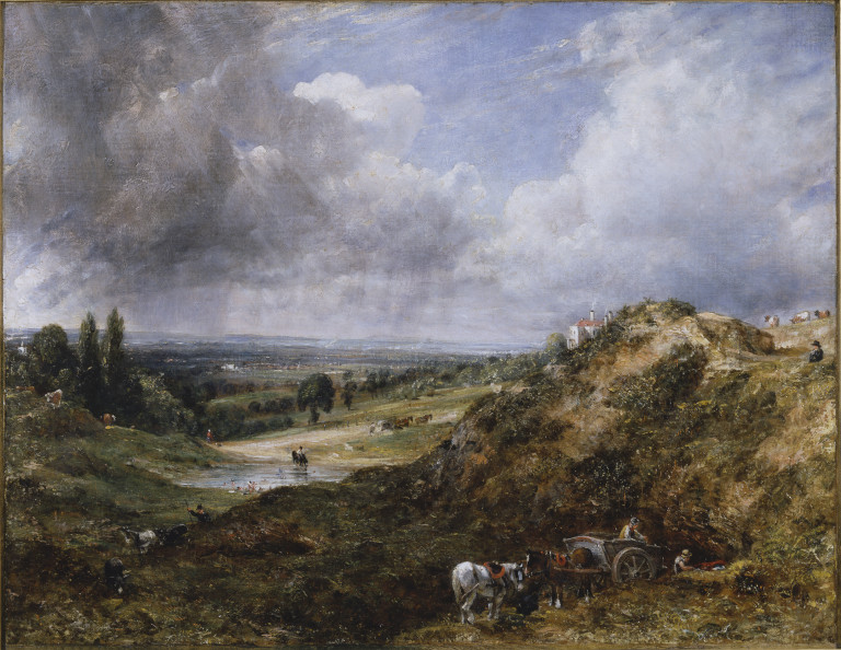
Constable’s Branch Hill Pond
Many will be familiar with John Constable’s paintings of the Branch Hill Pond. He painted over 20 versions, all of them while living in Hampstead between 1819 and 1837. They have spectacular skies which is one of his trademarks and the one below shows the magnificent view to Harrow-on-the-Hill on the right-hand side, sadly no longer visible because of the houses and the trees. Nevertheless, there is still a small view to the west between the houses on Branch Hill.

www.tate.org.uk/art/artworks/constable-hampstead-heath-with-harrow-in-the-distance-n01237
Some of the paintings show sand-digging on this small portion of Hampstead Heath, just to the southwest of the top section of West Heath Road, close to Whitestone Pond and the Flag Pole. They were quarrying the 50-million-year-old Bagshot Sand which covers the top of Hampstead Heath and although there is no direct evidence of the quarry, a trained eye can detect a bite out of the hillside above the pond. As well as evidence from Constable, the ‘dug ground’ is shown on the maps of the British Geological Survey (BGS) as well as contemporary maps of the area. All proved useful when it came to applying for permission to reinstate Constable’s Branch Hill Pond. The pond was filled in about 1889 and so archaeologists required proof that the area had been quarried or they would wish to undertake an archaeological survey which would take time and money. Mesolithic material had been found on West Heath and near Leg of Mutton Pond in the past. This is where the London Geodiversity Partnership came in and it was a simple job to provide the evidence for quarrying, thanks particularly to Constable and the BGS.

Branch Hill Pond, Hampstead with sand digging in the foreground.
Proposal to reinstate Branch Hill Pond
The Redington Frognal Association appointed Arup to carry out a survey of the area to highlight where natural waterways, ancient springs and ponds were once situated, partly with the intention of proposing ways of alleviating flooding in the area. Dr Adam Broadhead did an excellent job in tracing the routes of the former streams and speaking to residents about other aspects of the waterways which he combined into a map. Amongst other things he proposed the reinstating of the Branch Hill Pond as a means of attenuating the water that would otherwise flow into a culvert and thus put pressure on the sewer system. We believe there is a spring underlying the pond which would add to any runoff water during times of heavy rainfall. In my mind, this is one of the sources of the many tributaries that flow into the River Westbourne.
Reinstating the Branch Hill Pond would have the added advantage of increasing the biodiversity of this corner of Hampstead Heath, so the City of London Corporation welcomed the idea and were fully co-operative in achieving it. The intention is to encourage wildlife to the pond, in particular dragonflies and other insects which in turn would encourage amphibians, bats and birds. A fence would be erected to prevent contamination from dogs and planting around the pond would further encourage wildlife.
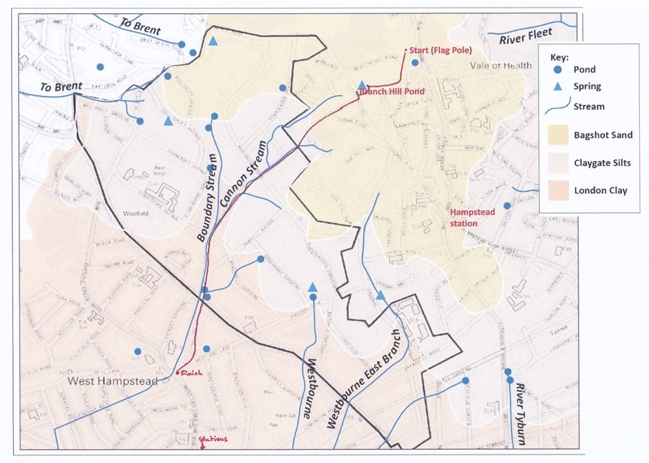
The red line is the route of the Geotrail I led from the Source of the Westbourne to West End Green.
Realising the dream
The Redington Frognal Association (RFA) did a huge amount of work publicising the plans to local residents. They held exhibitions locally in the JW3 Centre on the Finchley Road and in Burgh House in Hampstead. A series of 14 panels were produced with the help of LGP, Nancy Mayo (RFA) and Graphic Designer/local artist Dee McLean using many images researched by Robin Lacey. These explained not only all the aspects leading to the reinstating of Branch Hill Pond but other aspects of how flooding might be alleviated in the area. The boards can be viewed on the LGP website here and on The Redington Frognal Association website here.
Investigations were carried out, initiated by both the RFA and the City of London Corporation. Hydreau Consulting Engineers augured the area of the pond and advised on the findings which were incorporated into a plan by John Sheaff & Associates. Arup continued to be involved, while CoLC made their own assessment of the site and whether it would be advantageous to reinstate the pond here. Funding was obtained from a number of organisations: City Bridge Trust Enjoying Green Spaces the Natural Environment Fund; the Mayor of London’s Greener City Fund and local community infrastructure levy funding from the London Borough of Camden.
Decisions were made that the pond would be dug by CoLC at their expense and that it would have to be lined with puddling clay. A suggestion was put out to involve local people with the puddling as well as in the planting once the pond was established. It was intended to be about 1m deep with deeper refuges should the pond dry out in summer which can help sustain valuable habitats for aquatic life throughout the year.
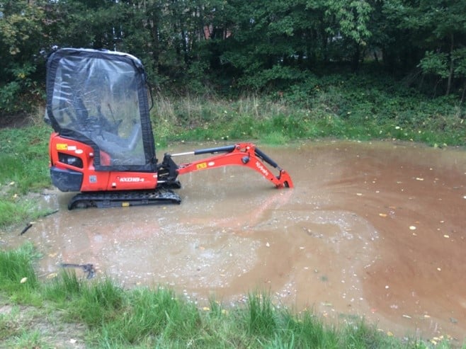
Digging was carried out in the hot August of 2022 but before it was completed a huge thunderstorm rapidly filled the pond. Despite the extremely hot summer of 2023, water remained in the pond and has never disappeared. It seems that the clay used in refilling the pond back in 1889 was a sufficient barrier and there would be no need for puddling. In September 2023 the CoLC digger braved the waters and extracted the underlying clay in a couple of locations to create refuges. I was anxious that these might become ‘plug holes’ and that the water might, after all, drain away through the Bagshot Sand. So far, my fears are unfounded.
Later in the autumn of 2023 Heath Hands, a local conservation and community charity, were prevailed upon to add the plants and 1000 plugs were dug in all round the pond and a fence erected to protect the water from contamination by dogs.
Sadly, the wet spring of 2024 caused the pond to flood beyond the fence, covering much of the planting. Fritillaries were flourishing in April, but I witnessed little else. It is unclear whether they may come back again, but wildlife is beginning to colonise the area and I look forward to seeing the species surveys and recording efforts aided by GiGL and others in the future. The good news is that the April flood water was well contained beneath the culvert and there were no reports of flooding further downstream in the Redington Frognal area.
It has been a privilege to be involved with this exciting project and we will look forward to continue working with the RFA to provide information on the pond and the route of the Westbourne. In the meantime we have designated it a Site of Geological Interest (SGI 37) soon to be added to the LGP website.
You will be able to read more about GiGL’s dip into mapping and surveying London’s ponds in November’s article on the new Pond Survey Project hosted by ZSL.